NATURE | VOL 394 | 9 JULY 1998
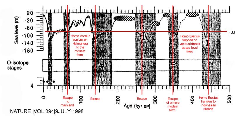
On this chart of sea-level history, I have drawn in a red horizontal line at the minus 80 meter below current mean sea-level index. That sea-level line correlates well with the time period when modern man broke out of his ancestral home land for the most recent and final time. This had to occur before 40,000 years ago at which time modern man suddenly appeared in Europe with an advanced culture. They must have developed that advanced culture over a considerable period of time at some location outside of Europe. These Cro Magnon people arrived in Europe with clothing,houses and advanced stone and bone tools. Therefore, these hairless, tropically adapted people had to have developed a near arctic cultural adaptation somewhere else. If they had come the short route from Africa they would not be in possession of these cold-weather cultural implements. Thus, it is more reasonable to assume that they developed these survival techniques in a cold environment such as would be found in north China or Mongolia, or on an outside chance it might have occurred in the mountains of Tibet. Once these physically-adapted-to-the-tropics people developed the requisite cultural cold weather adaptations and tools for living in north China, it would simply be a long walk to France, but an easy walk with plentiful game. The game would be more available because of their superior new-stone-age technology and they would easily displace the more primitive hunters without direct conflict. The culturally adapted-to living zone might be fairly narrow in a north-south direction but it would be very extensive in an east-west direction.
Recent evidence from Australian wall paintings indicates that modern symbol-using man had reached that region by 70,000 years ago which is even earlier by some 10s of thousands of years than they appeared in Europe. This makes an out-of-Africa hypothesis even more difficult to accept. How could a people who had found a livable environment in Africa move all the way to Australia, skipping over many desirable habitats, and do so without leaving a trace anywhere in between? The areas in between were much more habitable than the deserts of Australia, and yet there is no convincing evidence that these fully modern people were there during those times. If they were ever there some of their members would have stayed, developed and left an abundance of evidence. As there is none, the most reasonable assumption is that they were never there but they and their genes and their potential for culture arose east of India or Mongolia. There were Erectus-level people inhabiting all of these regions earlier and perhaps they still were there, but their material culture is sufficiently more primitive than that of any modern men so that it can be easily distinguished. There have been Erectus finds in China, and quite a lot of archeology has taken place recently in China and Japan, but no long and sustained development of culture from erectus to modern has been announced. Therefore, since the homeland should be apparent when it is finally located, it seems unlikely that the location has been in those general areas so far explored.
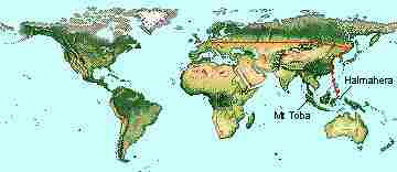
The easiest route from Eurasia to Australia, when the sea level was at its lowest, is through the island of Halmahera. This route doesn't require paddling out of sight of land, at least not for very long, whereas the route from Timor to Australia certainly does. Even as recently as Columbus's time, with much more experience and with much better ships, sailors were loath to leave the sight of land. How much more so a person paddling a log on the open sea? Perhaps the founding populations were occasionally blown out to sea by typhoons and then populated their new-found landing spot with their more modern genes. This method of population spreading is how many of the other creatures made the journey to new islands. It seems that fully modern humans should have been able to have some control over these journeys; even a person blown accidently from Halmahera to Celebes would try to get home and if he succeeded would inform his family and friends of the new land just over the horizon.
"Figure I Results for core Red Sea (19*23'24"N, 38*40'84"E, water depth 570m) AM variables plotted against time in calendar years (kyrBP) according to correlation with SPECMAPI.22. oxygen-isotope record (versus PDB standard) for <I>Globigerinoides ruber </I>in the 250-350 um size fraction (filled circles). Numbers refer to SPECMAP events22 filled diamonds indicate samples used for AMS radiocarbon darling (1,666 +\_ 26, 9.681 - 41 and 25,300 +\_ 200 radiocarbon years BP, respectively). B, Planktonic foraminifera per gram dry weight (thin line). Asterisks highlight true planktonic zones of oxygen isotope stages 2, 6and 12 which contain aragonitic coatings, cement and nodules. Heavy line is five-point moving-average highlighting the general trends. c, Benthic foraminifera gram dry weight (thin line), with five-point moving average (heavy line). We note factor 10 difference between scales in b and c. d, Down-core variation in TOC (%) LEW 125-CS elemental analyser). Preparation involved removal of carbonate by acidification using dilute hydrochloric acid. e, Abundance of melilotus relative to total benthic foraminifera fauna. Although of lower resolution than the other records, the miliolid percentages do show a general increase in abundance through the record, as well as peaks associated with the planktonic zones. f, Abundance of Globigerinoides ruber relative to total planktonic foraminifera fauna. 9, Abundance of SPRUDTS group relative to total planktonic foraminifera. This group represents a cluster of the individually infrequent subtropical species <I>Giobigerinoides sacculifer, Hastigerina pelagica, Globoturborotalia rubescens, Orbulina universa, Globigerina digitata, Globoturborotalia tenella and Globigerineflasiphonifera18. </I> h. Oxygen isotope stages22. 1, Global sea level record. The heavy solid line through the past 140kyr is based on benthic isotopes5 and the thin solid line through the post 200 kyr is based on coral reef terraces and benthicisotopes4 Cross-hatched ovals show reported ranges of interglacial sea-level highstands2-4.21 Thick error bars in stages 2, 6, 8. 10 and 12 represent ranges of glacial sea-level lowstands according to the model presented here. The dashed line through stages 8-12 shows schematic sea-level fluctuations sketched through the con" points following the main trends in the oxygen-isotope record."
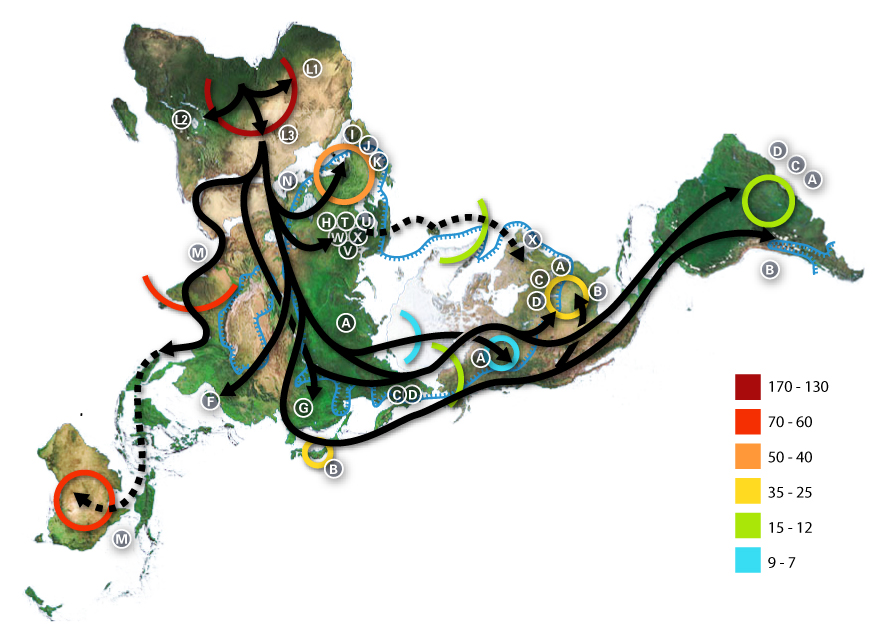
These pictures show when travel between islands would have been the shortest and presumably the
easiest.
This map shows modern vegetation zones which would differ greatly from mid-ice age vegetation zones; but as this extensive stretch of terrain is nearly flat a similar horizontal zone stretching across the north of Eurasia 30,000 years ago would have existed and it would have permitted a group of humans culturally adapted to north China to travel across the continent to France without having to develop any radically new technologies. Once the tropically adapted people had spread northward along the coast to Korea the same techniques for survival could be used in France and the trek across Asia would have gone very quickly. Moving north from the tropics to Korea may have taken 10,000 to 20,000 years but the traverse across Asia might have taken only a few years once a group decided that following the fresh game in the setting sun was a desirable thing to do.
Based on estimates of mutation rates, geneticist Henry Harpending says the bottleneck happened sometime after modern humans left Africa 100,000 years ago and before a population increase spurred by the advent of better stone tools around 50,000 years ago. Now archeologist Stan Ambrose of the University of Illinois has linked Harpending's
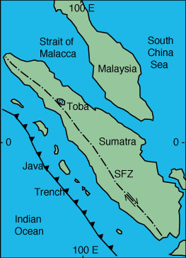
theory with geological evidence to explain what caused the bottleneck--a giant volcanic eruption.From geologist Michael Rampino of New York University, Ambrose learned that 71,000 years ago Mount Toba in Sumatra blew 800 to 2800 cubic kilometers of ash into the air--4,000 time as much as Mount St. Helens--the largest known volcanic eruption in more than 400 million years. Toba buried most of India under ash and must have darkened skies over a third of he hemisphere for weeks.
Toba caldera produced the largest eruption in the last 2 million years. The caldera is 18 x 60 miles (30 by 100 km) and has a total relief of 5,100 feet (1700 m). The caldera probably formed in stages. Large eruptions occurred 840,000, about 700,000, and 75,000 years ago. The eruption 75,000 years ago produced the Young Toba Tuff. The Young Toba Tuff was erupted from ring fractures that surround most or all of the present-day lake.
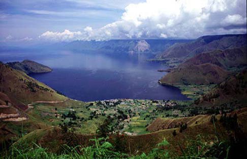 Pretty travel photo of Lake Toba showing just a portion of the
huge caldera lake. Lake Toba probably looks a lot like our ancestral eden.
Pretty travel photo of Lake Toba showing just a portion of the
huge caldera lake. Lake Toba probably looks a lot like our ancestral eden.
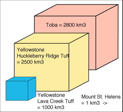 Comparison in cubic measure of these volcanic eruptions.
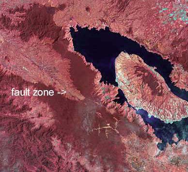 Photo
from space of Lake Toba.
Photo
from space of Lake Toba.Perhaps only a few thousand people, living in isolated pockets in Africa, Europe, and Asia, survived. When the climate warmed again, about 70,000 years ago, these isolated groups began to grow. Ambrose and Harpending think today's races are but a small sample of the human diversity that once existed. "Imagine the volcanic winter as a dirty, fractured prism," says Ambrose. "It's absorbing some wavelengths, or some genes, and others get through. Since the prism is dirty, a lot of the diversity gets absorbed. None comes out with all the original colors."
This article in Discovery Magazine discusses the eruption of Mt. Toba 71,000 years ago and its destructive effects on humanity worldwide. The article did not discuss one of the most important aspects of the worldwide ash layer - that is, the usefulness of this eruption for separating out various human evolutionary homeland theories. It provides a clear stratigraphic marker for archaeologists, and probably one for dendrochronologists as well. Before that time there are no known fully anatomically modern human archaeological sites anywhere in the world; and it is not evolutionarily speaking very long before fully modern Cro Magnon people appeared in Europe--a mere 30,000 years later; and Europe is a place where they almost certainly did not evolve. The eruption of Mt. Toba provides a worldwide ash layer which will discriminate perfectly where humanity's original developmental Eden lay, as any anatomically modern human discovered beneath that layer will be near the homeland. I know of no symbolic, that is human, artifacts, found near 71,000 years ago except perhaps in Australia, and the skeletons discovered there of that age are not fully modern; however, there are fully modern ones there at surprisingly ancient times. This would appear to preclude Africa as being the homeland, because modern man would require a long line of immediate precursor near-humans there. This "African homeland" would tend to cover a large area after a development of thousands of years, but these sites have not been discovered and therefore presumably do not exist. Also, the travelers from Africa would be forced to move through north Africa and the Nile and also the fertile crescent area on their journey to Australia. On that migration one would expect that they would leave settlements along the way and we would be finding symbolic level artifacts scattered along their path, but there are none from that time. Therefore, the most parsimonious explanation is that modern symbolic humans evolved somewhere closer to Australia. The easiest bridge of islands from Australia is through Halmahera and New Guinea but this raises the question of why didn't modern man evolve on New Guinea? Actually the highland valleys are promising sites, but I think the island is too big to maintain an ideal-sized interbreeding population of 6000 individuals. However, New Guinea should be seriously considered, especially as there are ancient farm sites there perhaps exceeding in age those of the fertile crescent. That date is one third of the way to the Cro-Magnon's early dates and is perhaps overlapping the dates of the later cave paintings in Europe. Furthermore, little archaeological work, that I know of, has taken place on New Guinea or on Halmahera.
The famous Institute of Human Origins created by Donald Johanson is looking in the wrong place and the wrong time strata for human origins. His group should have been named The Institute of Hominid Origins, but of course that wouldn't bring in much publicity or much money so its name was for the best. The problem with that institute's line of research is that it will end with some ancestor indistinguishable from an ape -- because it would have been an ape. The critical thing for early hominid evolution, and one which can never be found in the fossil record, would have been a behavioral change such as discussed in Probaway-Zanzibar. It will focus primarily . What is far more interesting than searching for increasingly more ape-like ancestors is finding increasingly less ape-like ancestors, that is, finding modern man's immediate precursors. What I propose is joining a group for researching the moment of humanity's birth and the precursors to that event, the greatest of all human events. Let this new group be called the Human Emergence Research Society. It will focus primarily on the period from about 500,000 years ago to the emergence of modern humans before about 30,000 years ago.
If you are interested please leave an email at probaway@gmail.comRapid Climate Change New evidence shows that earth’s climate can change dramatically in only a decade. Could greenhouse gases flip that switch? Keywords: earth climate history, climate cycle, glacial ice-core, anthropogenic effects, Greeland [sic], Antarctica, paleoclimate, hydrologic cycle, ocean-sediment core
Liability disclaimer statement: These Probaways contain new and unique information that has been created, tested and retested by me alone. You must approach these findings and materials very carefully as your results may differ greatly from my experience and I can offer no recompensation of any kind for any injuries.
